


parmain

mariejochat
User

Length
12.8 km

Max alt
142 m

Uphill gradient
236 m
Km-Effort
15.9 km

Min alt
26 m

Downhill gradient
235 m
Boucle
Yes
Creation date :
2019-11-12 08:37:33.367
Updated on :
2019-11-12 12:42:25.722
3h23
Difficulty : Very easy

FREE GPS app for hiking
 SityTrail
IGN / Geographical institutes
SityTrail Plus
The world is yours!
About
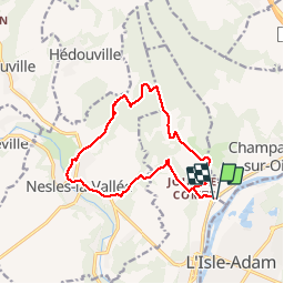
Trail Walking of 12.8 km to be discovered at Ile-de-France, Val-d'Oise, Parmain. This trail is proposed by mariejochat.
Positioning
Country:
France
Region :
Ile-de-France
Department/Province :
Val-d'Oise
Municipality :
Parmain
Location:
Unknown
Start:(Dec)
Start:(UTM)
442649 ; 5441681 (31U) N.
Comments