


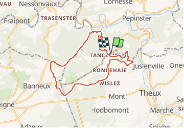
Tancremont eneo 15km

dechathys
User

Length
14.6 km

Max alt
330 m

Uphill gradient
303 m
Km-Effort
18.7 km

Min alt
144 m

Downhill gradient
303 m
Boucle
Yes
Creation date :
2019-11-12 08:56:36.688
Updated on :
2021-02-13 17:35:15.12
4h11
Difficulty : Very easy

FREE GPS app for hiking
 SityTrail
IGN / Geographical institutes
SityTrail Plus
The world is yours!
About
Trail Walking of 14.6 km to be discovered at Wallonia, Liège, Theux. This trail is proposed by dechathys.
Description
Balade guidée par Edmond le 12/11/2019
Positioning
Country:
Belgium
Region :
Wallonia
Department/Province :
Liège
Municipality :
Theux
Location:
Theux
Start:(Dec)
Start:(UTM)
697371 ; 5603710 (31U) N.
Comments