


villeny_Mon repos

lemuid
User
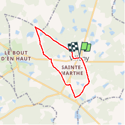

Length
10.5 km

Max alt
139 m

Uphill gradient
100 m
Km-Effort
11.8 km

Min alt
104 m

Downhill gradient
98 m
Boucle
Yes
Creation date :
2019-11-17 08:03:25.991
Updated on :
2019-11-17 17:02:50.182
2h24
Difficulty : Very easy

FREE GPS app for hiking
 SityTrail
IGN / Geographical institutes
SityTrail Plus
The world is yours!
About
Trail Walking of 10.5 km to be discovered at Centre-Loire Valley, Loir-et-Cher, Villeny. This trail is proposed by lemuid.
Positioning
Country:
France
Region :
Centre-Loire Valley
Department/Province :
Loir-et-Cher
Municipality :
Villeny
Location:
Unknown
Start:(Dec)
Start:(UTM)
406465 ; 5275163 (31T) N.
Comments