


Angire forêt

fournieralain
User
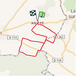

Length
6.9 km

Max alt
36 m

Uphill gradient
50 m
Km-Effort
7.6 km

Min alt
6 m

Downhill gradient
52 m
Boucle
Yes
Creation date :
2019-11-17 13:09:45.279
Updated on :
2019-11-17 14:40:34.333
1h18
Difficulty : Very easy

FREE GPS app for hiking
 SityTrail
IGN / Geographical institutes
SityTrail Plus
The world is yours!
About
Trail Walking of 6.9 km to be discovered at New Aquitaine, Charente-Maritime, Courçon. This trail is proposed by fournieralain.
Description
facile
Positioning
Country:
France
Region :
New Aquitaine
Department/Province :
Charente-Maritime
Municipality :
Courçon
Location:
Unknown
Start:(Dec)
Start:(UTM)
670574 ; 5124022 (30T) N.
Comments