


Dessin

UDGI54
User
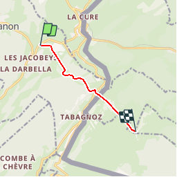

Length
5.5 km

Max alt
1671 m

Uphill gradient
698 m
Km-Effort
13.1 km

Min alt
1157 m

Downhill gradient
198 m
Boucle
No
Creation date :
2019-11-17 17:35:01.861
Updated on :
2019-11-17 17:35:20.595

FREE GPS app for hiking
 SityTrail
IGN / Geographical institutes
SityTrail Plus
The world is yours!
About
Trail of 5.5 km to be discovered at Bourgogne-Franche-Comté, Jura, Prémanon. This trail is proposed by UDGI54.
Description
Converted from a KML file KML2GPX.COM
Positioning
Country:
France
Region :
Bourgogne-Franche-Comté
Department/Province :
Jura
Municipality :
Prémanon
Location:
Unknown
Start:(Dec)
Start:(UTM)
273642 ; 5148844 (32T) N.
Comments