


Fleurie

Galoche
User

Length
17.6 km

Max alt
521 m

Uphill gradient
517 m
Km-Effort
24 km

Min alt
269 m

Downhill gradient
518 m
Boucle
Yes
Creation date :
2019-11-18 08:19:12.0
Updated on :
2019-11-18 13:51:41.704
4h53
Difficulty : Easy

FREE GPS app for hiking
 SityTrail
IGN / Geographical institutes
SityTrail Plus
The world is yours!
About
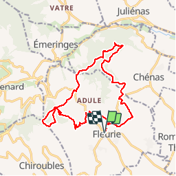
Trail Walking of 17.6 km to be discovered at Auvergne-Rhône-Alpes, Rhône, Fleurie. This trail is proposed by Galoche.
Photos


Positioning
Country:
France
Region :
Auvergne-Rhône-Alpes
Department/Province :
Rhône
Municipality :
Fleurie
Location:
Unknown
Start:(Dec)
Start:(UTM)
630950 ; 5116829 (31T) N.
Comments