


les anes

rcharlet
User
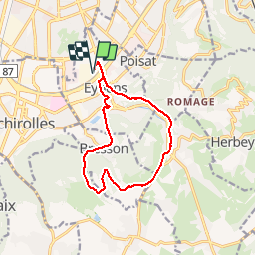

Length
12.5 km

Max alt
456 m

Uphill gradient
305 m
Km-Effort
16.6 km

Min alt
217 m

Downhill gradient
305 m
Boucle
Yes
Creation date :
2019-11-19 10:50:47.417
Updated on :
2019-11-19 12:12:11.592
1h23
Difficulty : Very easy

FREE GPS app for hiking
 SityTrail
IGN / Geographical institutes
SityTrail Plus
The world is yours!
About
Trail Running of 12.5 km to be discovered at Auvergne-Rhône-Alpes, Isère, Eybens. This trail is proposed by rcharlet.
Positioning
Country:
France
Region :
Auvergne-Rhône-Alpes
Department/Province :
Isère
Municipality :
Eybens
Location:
Unknown
Start:(Dec)
Start:(UTM)
715688 ; 5003892 (31T) N.
Comments