


rando clape Christian

Daron34
User
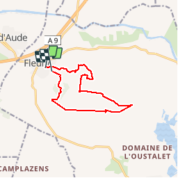

Length
11.9 km

Max alt
163 m

Uphill gradient
297 m
Km-Effort
15.8 km

Min alt
39 m

Downhill gradient
275 m
Boucle
No
Creation date :
2019-11-19 12:33:03.525
Updated on :
2019-11-19 15:52:08.51
3h18
Difficulty : Medium

FREE GPS app for hiking
 SityTrail
IGN / Geographical institutes
SityTrail Plus
The world is yours!
About
Trail Walking of 11.9 km to be discovered at Occitania, Aude, Fleury. This trail is proposed by Daron34.
Description
.boucle
Positioning
Country:
France
Region :
Occitania
Department/Province :
Aude
Municipality :
Fleury
Location:
Unknown
Start:(Dec)
Start:(UTM)
511238 ; 4786136 (31T) N.
Comments