


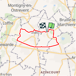
ecaillon, circuit des sources version 9 km 500

papiou
User

Length
9.5 km

Max alt
31 m

Uphill gradient
47 m
Km-Effort
10.1 km

Min alt
18 m

Downhill gradient
47 m
Boucle
Yes
Creation date :
2019-11-17 08:03:45.028
Updated on :
2019-11-20 12:24:11.377
2h03
Difficulty : Easy

FREE GPS app for hiking
 SityTrail
IGN / Geographical institutes
SityTrail Plus
The world is yours!
About
Trail Walking of 9.5 km to be discovered at Hauts-de-France, Nord, Écaillon. This trail is proposed by papiou.
Description
rdv face salle des fêtes et suivre parcours
Positioning
Country:
France
Region :
Hauts-de-France
Department/Province :
Nord
Municipality :
Écaillon
Location:
Unknown
Start:(Dec)
Start:(UTM)
515358 ; 5577534 (31U) N.
Comments