


de font du griffe à Saint guilhem

labarone
User
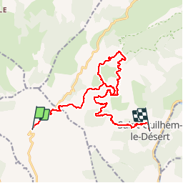

Length
17.8 km

Max alt
514 m

Uphill gradient
569 m
Km-Effort
26 km

Min alt
107 m

Downhill gradient
862 m
Boucle
No
Creation date :
2019-11-20 08:13:00.997
Updated on :
2019-11-20 13:57:26.687
5h07
Difficulty : Easy

FREE GPS app for hiking
 SityTrail
IGN / Geographical institutes
SityTrail Plus
The world is yours!
About
Trail Walking of 17.8 km to be discovered at Occitania, Hérault, Montpeyroux. This trail is proposed by labarone.
Description
On y a trouvé un chien de chasse et on l'a ramené à son maître... À voir :les fenestrelles, les arbouses et les bruyères...
Positioning
Country:
France
Region :
Occitania
Department/Province :
Hérault
Municipality :
Montpeyroux
Location:
Unknown
Start:(Dec)
Start:(UTM)
539626 ; 4842516 (31T) N.
Comments