


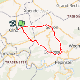
Olne Soiron 10kms
© OpenStreetMap contributors


--
Difficulty : Medium


Length
10.2 km
Max alt
281 m
Uphill gradient
275 m
Km-Effort
13.8 km
Min alt
167 m
Downhill gradient
275 m
Boucle
Yes
Creation date :
2019-11-21 11:45:35.563
Updated on :
2019-11-21 11:46:31.769
--
Difficulty : Medium
FREE GPS app for hiking
 SityTrail
IGN / Geographical institutes
SityTrail Plus
The world is yours!
About
Trail On foot of 10.2 km to be discovered at Wallonia, Liège, Olne. This trail is proposed by andre.forthomme@gmail.com.
Positioning
Country:
Belgium
Region :
Wallonia
Department/Province :
Liège
Municipality :
Olne
Location:
Olne
Start:(Dec)
Start:(UTM)
694810 ; 5607824 (31U) N.
Comments