


Les Hautes Londes 4

rollondesbois
User
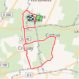

Length
8 km

Max alt
78 m

Uphill gradient
68 m
Km-Effort
8.9 km

Min alt
38 m

Downhill gradient
68 m
Boucle
Yes
Creation date :
2019-11-21 21:52:44.106
Updated on :
2019-11-21 21:53:45.889
1h30
Difficulty : Medium

FREE GPS app for hiking
 SityTrail
IGN / Geographical institutes
SityTrail Plus
The world is yours!
About
Trail On foot of 8 km to be discovered at Normandy, Calvados, Tour-en-Bessin. This trail is proposed by rollondesbois.
Description
8km
Positioning
Country:
France
Region :
Normandy
Department/Province :
Calvados
Municipality :
Tour-en-Bessin
Location:
Unknown
Start:(Dec)
Start:(UTM)
659858 ; 5460494 (30U) N.
Comments