Trail Walking Lioux - Forêt de St Lambert - Photo
© OpenStreetMap contributors
Length
Length
14.3 km
Max alt
Max alt
766 m
Uphill gradient
Uphill gradient
472 m
Km-Effort
Km-Effort  
21 km
Min alt
Min alt
478 m
Downhill gradient
Downhill gradient
475 m
Boucle
Boucle
Yes
Creation date :
2014-12-10 00:00:00.0
Updated on :
2014-12-10 00:00:00.0

(0 Reviews)

Walking
Walking
3h28
Difficulty : Medium

Scan this QR Code to open this trail in the SityTrail application

FREE GPS app for hiking

Logo SityTrail SityTrail

IGN / Geographical institutes

Download SityTrail from the App Store Download SityTrail from Google Play

Logo SityTrail SityTrail Plus

The world is yours!

Download SityTrail from the App Store Download SityTrail from Google Play Download SityTrail on Huawei AppGallery

About

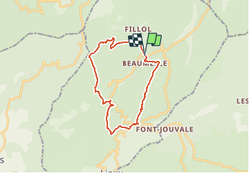
Trail Walking of 14.3 km to be discovered at Provence-Alpes-Côte d'Azur, Vaucluse, Lioux. This trail is proposed by MarcLEBARON.

Description

Boucle autour de la forêt domaniale de St Lambert.
La 1ère moitié jusqu'à la sortie de la Combe de Lioux est facile.
La 2ème est plus compliquée passage hors sentier "secteur le bois brulé" et ensuite remontée par la vallon de Jas sur sentier très restreint et fermé (ne me semble pas accessible en famille).

Elevation profile

Positioning

Country:
France
Region :
Provence-Alpes-Côte d'Azur
Department/Province :
Vaucluse
Municipality :
Lioux
Location:
Unknown
Start:(UTM)
685845 ; 4873239 (31T) N.


Close
My subscriptions