Trail Walking Valenciennes - le vignoble au départ de Lacuzon - Photo

le vignoble au départ de Lacuzon

 papiou
papiou

User

© OpenStreetMap contributors
Length
Length
7 km
Max alt
Max alt
33 m
Uphill gradient
Uphill gradient
52 m
Km-Effort
Km-Effort  
7.7 km
Min alt
Min alt
18 m
Downhill gradient
Downhill gradient
52 m
Boucle
Boucle
Yes
Creation date :
2019-11-24 08:15:37.012
Updated on :
2019-11-24 18:34:44.275

(0 Reviews)

Walking
Walking
1h46
Difficulty : Very easy

Scan this QR Code to open this trail in the SityTrail application

FREE GPS app for hiking

Logo SityTrail SityTrail

IGN / Geographical institutes

Download SityTrail from the App Store Download SityTrail from Google Play

Logo SityTrail SityTrail Plus

The world is yours!

Download SityTrail from the App Store Download SityTrail from Google Play Download SityTrail on Huawei AppGallery

About

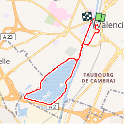
Trail Walking of 7 km to be discovered at Hauts-de-France, Nord, Valenciennes. This trail is proposed by papiou.

Description

rdv parking Lacuzon et visiter vestiges de Vauban de l'autre côté de la route puis rejoindre Pont Faidherbe par la route et rejoindre le vignoble par berge de l'Escaut, faire le tour de l'étang puis revenir point de départ par berge et pont Villars

Elevation profile

Positioning

Country:
France
Region :
Hauts-de-France
Department/Province :
Nord
Municipality :
Valenciennes
Location:
Unknown
Start:(UTM)
536538 ; 5578470 (31U) N.


Close
My subscriptions