


Rando Le Luhier

TRIMAILLE
User
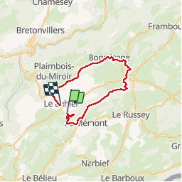

Length
20 km

Max alt
1047 m

Uphill gradient
524 m
Km-Effort
27 km

Min alt
784 m

Downhill gradient
566 m
Boucle
No
Creation date :
2019-11-24 22:16:16.455
Updated on :
2019-11-27 16:34:11.635
5h47
Difficulty : Difficult

FREE GPS app for hiking
 SityTrail
IGN / Geographical institutes
SityTrail Plus
The world is yours!
About
Trail Walking of 20 km to be discovered at Bourgogne-Franche-Comté, Doubs, Le Luhier. This trail is proposed by TRIMAILLE.
Positioning
Country:
France
Region :
Bourgogne-Franche-Comté
Department/Province :
Doubs
Municipality :
Le Luhier
Location:
Unknown
Start:(Dec)
Start:(UTM)
322813 ; 5225917 (32T) N.
Comments