


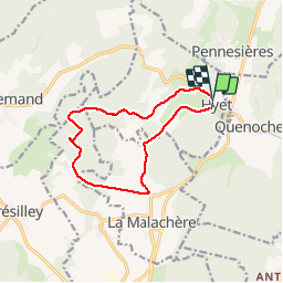
Rando Hyet

TRIMAILLE
User

Length
11 km

Max alt
409 m

Uphill gradient
228 m
Km-Effort
14 km

Min alt
284 m

Downhill gradient
227 m
Boucle
Yes
Creation date :
2019-11-24 22:18:08.462
Updated on :
2019-11-27 16:33:09.736
3h01
Difficulty : Easy

FREE GPS app for hiking
 SityTrail
IGN / Geographical institutes
SityTrail Plus
The world is yours!
About
Trail Walking of 11 km to be discovered at Bourgogne-Franche-Comté, Haute-Saône, Hyet. This trail is proposed by TRIMAILLE.
Positioning
Country:
France
Region :
Bourgogne-Franche-Comté
Department/Province :
Haute-Saône
Municipality :
Hyet
Location:
Unknown
Start:(Dec)
Start:(UTM)
280902 ; 5261791 (32T) N.
Comments