


Rando Chalèze- Arcier

TRIMAILLE
User
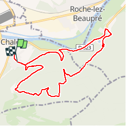

Length
10.5 km

Max alt
517 m

Uphill gradient
433 m
Km-Effort
16.2 km

Min alt
246 m

Downhill gradient
424 m
Boucle
No
Creation date :
2019-11-25 08:04:34.973
Updated on :
2019-11-27 16:32:03.727
3h21
Difficulty : Medium

FREE GPS app for hiking
 SityTrail
IGN / Geographical institutes
SityTrail Plus
The world is yours!
About
Trail Walking of 10.5 km to be discovered at Bourgogne-Franche-Comté, Doubs, Chalèze. This trail is proposed by TRIMAILLE.
Positioning
Country:
France
Region :
Bourgogne-Franche-Comté
Department/Province :
Doubs
Municipality :
Chalèze
Location:
Unknown
Start:(Dec)
Start:(UTM)
279901 ; 5238750 (32T) N.
Comments