


Rando Châtillon Guyot

TRIMAILLE
User
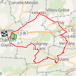

Length
21 km

Max alt
425 m

Uphill gradient
410 m
Km-Effort
26 km

Min alt
258 m

Downhill gradient
394 m
Boucle
No
Creation date :
2019-11-25 08:15:18.778
Updated on :
2019-11-27 16:28:37.8
5h41
Difficulty : Medium

FREE GPS app for hiking
 SityTrail
IGN / Geographical institutes
SityTrail Plus
The world is yours!
About
Trail Walking of 21 km to be discovered at Bourgogne-Franche-Comté, Doubs, Châtillon-Guyotte. This trail is proposed by TRIMAILLE.
Positioning
Country:
France
Region :
Bourgogne-Franche-Comté
Department/Province :
Doubs
Municipality :
Châtillon-Guyotte
Location:
Unknown
Start:(Dec)
Start:(UTM)
286223 ; 5245624 (32T) N.
Comments