


Rando Bucey-lès-Gy

TRIMAILLE
User
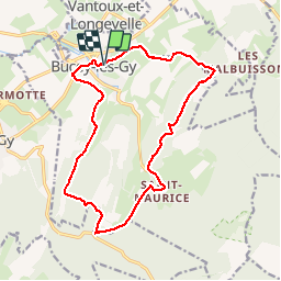

Length
16.1 km

Max alt
390 m

Uphill gradient
370 m
Km-Effort
21 km

Min alt
212 m

Downhill gradient
371 m
Boucle
Yes
Creation date :
2019-11-25 08:52:23.588
Updated on :
2019-11-27 10:26:01.48
4h30
Difficulty : Very difficult

FREE GPS app for hiking
 SityTrail
IGN / Geographical institutes
SityTrail Plus
The world is yours!
About
Trail Walking of 16.1 km to be discovered at Bourgogne-Franche-Comté, Haute-Saône, Bucey-lès-Gy. This trail is proposed by TRIMAILLE.
Positioning
Country:
France
Region :
Bourgogne-Franche-Comté
Department/Province :
Haute-Saône
Municipality :
Bucey-lès-Gy
Location:
Unknown
Start:(Dec)
Start:(UTM)
714665 ; 5256082 (31T) N.
Comments