


Rando Nans sous St Anne

TRIMAILLE
User
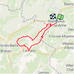

Length
24 km

Max alt
744 m

Uphill gradient
606 m
Km-Effort
32 km

Min alt
364 m

Downhill gradient
615 m
Boucle
Yes
Creation date :
2019-11-25 09:04:52.99
Updated on :
2019-11-27 10:31:25.115
6h47
Difficulty : Very difficult

FREE GPS app for hiking
 SityTrail
IGN / Geographical institutes
SityTrail Plus
The world is yours!
About
Trail Walking of 24 km to be discovered at Bourgogne-Franche-Comté, Doubs, Nans-sous-Sainte-Anne. This trail is proposed by TRIMAILLE.
Positioning
Country:
France
Region :
Bourgogne-Franche-Comté
Department/Province :
Doubs
Municipality :
Nans-sous-Sainte-Anne
Location:
Unknown
Start:(Dec)
Start:(UTM)
728000 ; 5206865 (31T) N.
Comments