


Rando Fontaine-lès-Dijon

TRIMAILLE
User
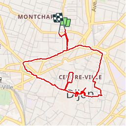

Length
4.9 km

Max alt
258 m

Uphill gradient
33 m
Km-Effort
5.3 km

Min alt
245 m

Downhill gradient
38 m
Boucle
Yes
Creation date :
2019-11-25 09:10:09.468
Updated on :
2019-11-27 10:30:40.724
1h10
Difficulty : Easy

FREE GPS app for hiking
 SityTrail
IGN / Geographical institutes
SityTrail Plus
The world is yours!
About
Trail Walking of 4.9 km to be discovered at Bourgogne-Franche-Comté, Côte-d'Or, Dijon. This trail is proposed by TRIMAILLE.
Positioning
Country:
France
Region :
Bourgogne-Franche-Comté
Department/Province :
Côte-d'Or
Municipality :
Dijon
Location:
Unknown
Start:(Dec)
Start:(UTM)
653965 ; 5243709 (31T) N.
Comments