


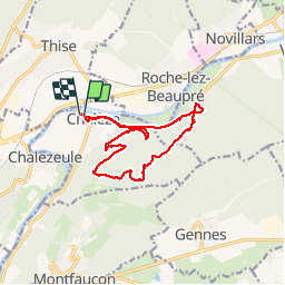
Rando Chaléze CKCC

TRIMAILLE
User

Length
12.8 km

Max alt
517 m

Uphill gradient
469 m
Km-Effort
19 km

Min alt
244 m

Downhill gradient
471 m
Boucle
Yes
Creation date :
2019-11-25 09:18:00.76
Updated on :
2019-11-27 10:34:08.026
3h58
Difficulty : Difficult

FREE GPS app for hiking
 SityTrail
IGN / Geographical institutes
SityTrail Plus
The world is yours!
About
Trail Walking of 12.8 km to be discovered at Bourgogne-Franche-Comté, Doubs, Chalèze. This trail is proposed by TRIMAILLE.
Positioning
Country:
France
Region :
Bourgogne-Franche-Comté
Department/Province :
Doubs
Municipality :
Chalèze
Location:
Unknown
Start:(Dec)
Start:(UTM)
279676 ; 5239159 (32T) N.
Comments