


Rando Bonlieu cascades du Hérisson

TRIMAILLE
User
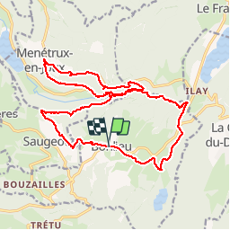

Length
22 km

Max alt
828 m

Uphill gradient
712 m
Km-Effort
32 km

Min alt
525 m

Downhill gradient
707 m
Boucle
Yes
Creation date :
2019-11-25 09:19:59.577
Updated on :
2019-11-27 10:35:00.028
6h43
Difficulty : Difficult

FREE GPS app for hiking
 SityTrail
IGN / Geographical institutes
SityTrail Plus
The world is yours!
About
Trail Walking of 22 km to be discovered at Bourgogne-Franche-Comté, Jura, Bonlieu. This trail is proposed by TRIMAILLE.
Positioning
Country:
France
Region :
Bourgogne-Franche-Comté
Department/Province :
Jura
Municipality :
Bonlieu
Location:
Unknown
Start:(Dec)
Start:(UTM)
718532 ; 5164722 (31T) N.
Comments