


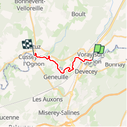
Kayak Voray à Cussey sur l'Oignon

TRIMAILLE
User

Length
10.7 km

Max alt
234 m

Uphill gradient
62 m
Km-Effort
11.5 km

Min alt
208 m

Downhill gradient
67 m
Boucle
No
Creation date :
2019-11-25 09:22:11.396
Updated on :
2019-11-27 10:35:46.765
2h47
Difficulty : Very easy

FREE GPS app for hiking
 SityTrail
IGN / Geographical institutes
SityTrail Plus
The world is yours!
About
Trail Canoe - kayak of 10.7 km to be discovered at Bourgogne-Franche-Comté, Haute-Saône, Voray-sur-l'Ognon. This trail is proposed by TRIMAILLE.
Positioning
Country:
France
Region :
Bourgogne-Franche-Comté
Department/Province :
Haute-Saône
Municipality :
Voray-sur-l'Ognon
Location:
Unknown
Start:(Dec)
Start:(UTM)
274853 ; 5247042 (32T) N.
Comments