


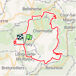
Rando Chamesey

TRIMAILLE
User

Length
22 km

Max alt
845 m

Uphill gradient
692 m
Km-Effort
31 km

Min alt
491 m

Downhill gradient
696 m
Boucle
Yes
Creation date :
2019-11-25 09:25:37.986
Updated on :
2019-11-27 10:36:46.007
6h28
Difficulty : Difficult

FREE GPS app for hiking
 SityTrail
IGN / Geographical institutes
SityTrail Plus
The world is yours!
About
Trail Walking of 22 km to be discovered at Bourgogne-Franche-Comté, Doubs, Chamesey. This trail is proposed by TRIMAILLE.
Positioning
Country:
France
Region :
Bourgogne-Franche-Comté
Department/Province :
Doubs
Municipality :
Chamesey
Location:
Unknown
Start:(Dec)
Start:(UTM)
322172 ; 5234129 (32T) N.
Comments