


nordique 10km

jeanmarcMasson
User GUIDE
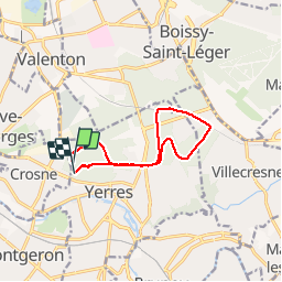

Length
9.7 km

Max alt
122 m

Uphill gradient
107 m
Km-Effort
11.1 km

Min alt
88 m

Downhill gradient
101 m
Boucle
No
Creation date :
2019-11-25 08:43:19.134
Updated on :
2019-11-25 10:31:37.468
1h47
Difficulty : Easy

FREE GPS app for hiking
 SityTrail
IGN / Geographical institutes
SityTrail Plus
The world is yours!
About
Trail Nordic walking of 9.7 km to be discovered at Ile-de-France, Essonne, Yerres. This trail is proposed by jeanmarcMasson.
Positioning
Country:
France
Region :
Ile-de-France
Department/Province :
Essonne
Municipality :
Yerres
Location:
Unknown
Start:(Dec)
Start:(UTM)
461549 ; 5396763 (31U) N.
Comments