


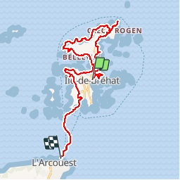
Rando Ile de Brehat

TRIMAILLE
User

Length
16.3 km

Max alt
22 m

Uphill gradient
148 m
Km-Effort
18.3 km

Min alt
-1 m

Downhill gradient
161 m
Boucle
No
Creation date :
2019-11-25 11:20:20.269
Updated on :
2019-11-25 18:20:21.729
4h01
Difficulty : Difficult

FREE GPS app for hiking
 SityTrail
IGN / Geographical institutes
SityTrail Plus
The world is yours!
About
Trail Walking of 16.3 km to be discovered at Brittany, Côtes-d'Armor, Île-de-Bréhat. This trail is proposed by TRIMAILLE.
Positioning
Country:
France
Region :
Brittany
Department/Province :
Côtes-d'Armor
Municipality :
Île-de-Bréhat
Location:
Unknown
Start:(Dec)
Start:(UTM)
500106 ; 5410426 (30U) N.
Comments