


Rando Pordic

TRIMAILLE
User
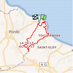

Length
10.7 km

Max alt
112 m

Uphill gradient
214 m
Km-Effort
13.6 km

Min alt
4 m

Downhill gradient
215 m
Boucle
Yes
Creation date :
2019-11-25 11:21:53.672
Updated on :
2019-11-25 18:19:55.265
2h55
Difficulty : Difficult

FREE GPS app for hiking
 SityTrail
IGN / Geographical institutes
SityTrail Plus
The world is yours!
About
Trail Walking of 10.7 km to be discovered at Brittany, Côtes-d'Armor, Pordic. This trail is proposed by TRIMAILLE.
Positioning
Country:
France
Region :
Brittany
Department/Province :
Côtes-d'Armor
Municipality :
Pordic
Location:
Pordic
Start:(Dec)
Start:(UTM)
515941 ; 5380632 (30U) N.
Comments