


Rando Marcieu

TRIMAILLE
User
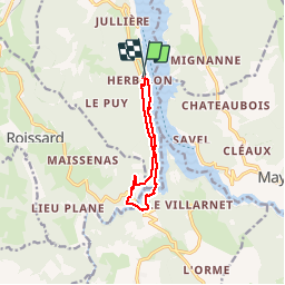

Length
9.1 km

Max alt
729 m

Uphill gradient
424 m
Km-Effort
14.8 km

Min alt
480 m

Downhill gradient
442 m
Boucle
Yes
Creation date :
2019-11-25 11:41:55.251
Updated on :
2019-11-25 18:11:34.272
3h01
Difficulty : Difficult

FREE GPS app for hiking
 SityTrail
IGN / Geographical institutes
SityTrail Plus
The world is yours!
About
Trail Walking of 9.1 km to be discovered at Auvergne-Rhône-Alpes, Isère, Treffort. This trail is proposed by TRIMAILLE.
Positioning
Country:
France
Region :
Auvergne-Rhône-Alpes
Department/Province :
Isère
Municipality :
Treffort
Location:
Unknown
Start:(Dec)
Start:(UTM)
711045 ; 4974890 (31T) N.
Comments