


VALLEE DU LOING

NUITEVEN
User
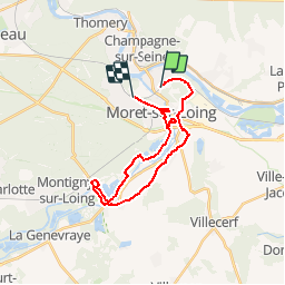

Length
23 km

Max alt
105 m

Uphill gradient
242 m
Km-Effort
26 km

Min alt
45 m

Downhill gradient
240 m
Boucle
No
Creation date :
2017-10-02 00:00:00.0
Updated on :
2017-10-02 00:00:00.0
5h38
Difficulty : Easy

FREE GPS app for hiking
 SityTrail
IGN / Geographical institutes
SityTrail Plus
The world is yours!
About
Trail Walking of 23 km to be discovered at Ile-de-France, Seine-et-Marne, Saint-Mammès. This trail is proposed by NUITEVEN.
Positioning
Country:
France
Region :
Ile-de-France
Department/Province :
Seine-et-Marne
Municipality :
Saint-Mammès
Location:
Unknown
Start:(Dec)
Start:(UTM)
486360 ; 5358814 (31U) N.
Comments