


fosseuse

avdem
User

Length
99 m

Max alt
54 m

Uphill gradient
1 m
Km-Effort
109 m

Min alt
51 m

Downhill gradient
0 m
Boucle
No
Creation date :
2019-11-26 08:27:48.586
Updated on :
2019-11-26 08:38:12.521
1m
Difficulty : Very easy

FREE GPS app for hiking
 SityTrail
IGN / Geographical institutes
SityTrail Plus
The world is yours!
About
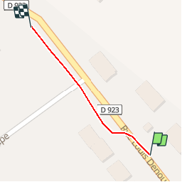
Trail Walking of 99 m to be discovered at Hauts-de-France, Oise, Bornel. This trail is proposed by avdem.
Description
tour de Fosseuse
Positioning
Country:
France
Region :
Hauts-de-France
Department/Province :
Oise
Municipality :
Bornel
Location:
Bornel
Start:(Dec)
Start:(UTM)
441833 ; 5450418 (31U) N.
Comments