


Rando Forges les eaux 31 Aout 2025 AM

maillebreze
User

Length
12.6 km

Max alt
165 m

Uphill gradient
110 m
Km-Effort
14 km

Min alt
125 m

Downhill gradient
110 m
Boucle
Yes
Creation date :
2019-11-26 09:13:27.888
Updated on :
2025-07-15 16:34:55.969
3h11
Difficulty : Easy

FREE GPS app for hiking
 SityTrail
IGN / Geographical institutes
SityTrail Plus
The world is yours!
About
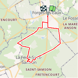
Trail On foot of 12.6 km to be discovered at Normandy, Seine-Maritime, Forges-les-Eaux. This trail is proposed by maillebreze.
Positioning
Country:
France
Region :
Normandy
Department/Province :
Seine-Maritime
Municipality :
Forges-les-Eaux
Location:
Forges-les-Eaux
Start:(Dec)
Start:(UTM)
393742 ; 5496162 (31U) N.
Comments