26 11 2020 le revard

Valmeinier
User
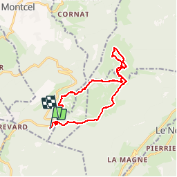

Length
13.3 km

Max alt
1415 m

Uphill gradient
417 m
Km-Effort
19.1 km

Min alt
1127 m

Downhill gradient
477 m
Boucle
No
Creation date :
2019-11-26 07:56:37.727
Updated on :
2019-11-26 13:55:51.852
5h57
Difficulty : Very easy

FREE GPS app for hiking
 SityTrail
IGN / Geographical institutes
SityTrail Plus
The world is yours!
About
Trail Walking of 13.3 km to be discovered at Auvergne-Rhône-Alpes, Savoy, Montcel. This trail is proposed by Valmeinier.
Positioning
Country:
France
Region :
Auvergne-Rhône-Alpes
Department/Province :
Savoy
Municipality :
Montcel
Location:
Unknown
Start:(Dec)
Start:(UTM)
733552 ; 5062849 (31T) N.
Comments