


2019-11-26_23h20m49_Les Hauts de Champagne

avdem
User
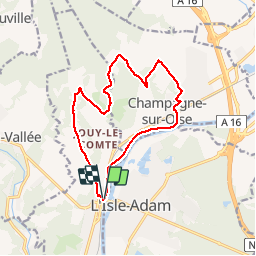

Length
13.1 km

Max alt
117 m

Uphill gradient
219 m
Km-Effort
16 km

Min alt
20 m

Downhill gradient
215 m
Boucle
Yes
Creation date :
2019-11-26 22:20:52.984
Updated on :
2019-11-26 22:20:56.196

FREE GPS app for hiking
 SityTrail
IGN / Geographical institutes
SityTrail Plus
The world is yours!
About
Trail of 13.1 km to be discovered at Ile-de-France, Val-d'Oise, Parmain. This trail is proposed by avdem.
Positioning
Country:
France
Region :
Ile-de-France
Department/Province :
Val-d'Oise
Municipality :
Parmain
Location:
Unknown
Start:(Dec)
Start:(UTM)
442324 ; 5440454 (31U) N.
Comments