


Vielsalm As

pierlan
User
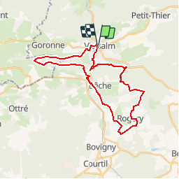

Length
28 km

Max alt
547 m

Uphill gradient
641 m
Km-Effort
37 km

Min alt
348 m

Downhill gradient
649 m
Boucle
Yes
Creation date :
2019-11-26 13:07:53.214
Updated on :
2019-11-27 16:40:56.976
6h00
Difficulty : Very easy

FREE GPS app for hiking
 SityTrail
IGN / Geographical institutes
SityTrail Plus
The world is yours!
About
Trail Trail of 28 km to be discovered at Wallonia, Luxembourg, Vielsalm. This trail is proposed by pierlan.
Positioning
Country:
Belgium
Region :
Wallonia
Department/Province :
Luxembourg
Municipality :
Vielsalm
Location:
Vielsalm
Start:(Dec)
Start:(UTM)
707669 ; 5574558 (31U) N.
Comments