


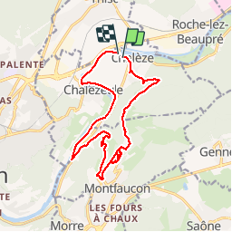
Rando Chalèze

TRIMAILLE
User

Length
16.6 km

Max alt
615 m

Uphill gradient
445 m
Km-Effort
23 km

Min alt
240 m

Downhill gradient
447 m
Boucle
Yes
Creation date :
2019-11-27 16:45:22.472
Updated on :
2019-11-27 16:46:31.851
--
Difficulty : Medium

FREE GPS app for hiking
 SityTrail
IGN / Geographical institutes
SityTrail Plus
The world is yours!
About
Trail Walking of 16.6 km to be discovered at Bourgogne-Franche-Comté, Doubs, Chalèze. This trail is proposed by TRIMAILLE.
Positioning
Country:
France
Region :
Bourgogne-Franche-Comté
Department/Province :
Doubs
Municipality :
Chalèze
Location:
Unknown
Start:(Dec)
Start:(UTM)
279608 ; 5239100 (32T) N.
Comments