


Rando Montgesoye

TRIMAILLE
User
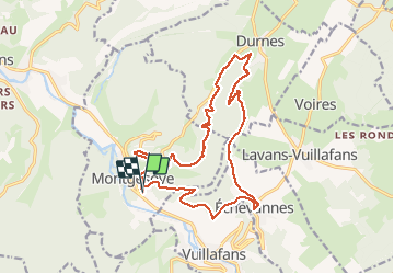

Length
17.9 km

Max alt
649 m

Uphill gradient
527 m
Km-Effort
25 km

Min alt
344 m

Downhill gradient
532 m
Boucle
Yes
Creation date :
2019-11-27 16:57:42.669
Updated on :
2019-12-11 11:11:15.768
5h16
Difficulty : Difficult

FREE GPS app for hiking
 SityTrail
IGN / Geographical institutes
SityTrail Plus
The world is yours!
About
Trail Walking of 17.9 km to be discovered at Bourgogne-Franche-Comté, Doubs. This trail is proposed by TRIMAILLE.
Positioning
Country:
France
Region :
Bourgogne-Franche-Comté
Department/Province :
Doubs
Municipality :
MONTGESOYE
Location:
Unknown
Start:(Dec)
Start:(UTM)
286987 ; 5217772 (32T) N.
Comments