


Rando Balazuc

TRIMAILLE
User
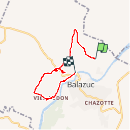

Length
6.1 km

Max alt
233 m

Uphill gradient
169 m
Km-Effort
8.4 km

Min alt
129 m

Downhill gradient
195 m
Boucle
No
Creation date :
2019-11-27 17:00:04.552
Updated on :
2019-11-27 17:00:52.307
1h46
Difficulty : Very easy

FREE GPS app for hiking
 SityTrail
IGN / Geographical institutes
SityTrail Plus
The world is yours!
About
Trail Walking of 6.1 km to be discovered at Auvergne-Rhône-Alpes, Ardèche, Balazuc. This trail is proposed by TRIMAILLE.
Positioning
Country:
France
Region :
Auvergne-Rhône-Alpes
Department/Province :
Ardèche
Municipality :
Balazuc
Location:
Unknown
Start:(Dec)
Start:(UTM)
609507 ; 4930031 (31T) N.
Comments