


Rando Salavas

TRIMAILLE
User
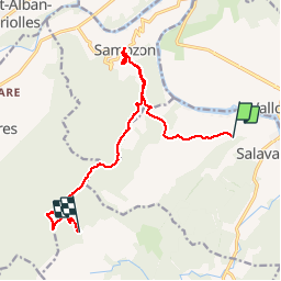

Length
14.5 km

Max alt
546 m

Uphill gradient
623 m
Km-Effort
22 km

Min alt
94 m

Downhill gradient
394 m
Boucle
No
Creation date :
2019-11-27 17:03:52.571
Updated on :
2019-11-27 17:05:02.787
4h42
Difficulty : Medium

FREE GPS app for hiking
 SityTrail
IGN / Geographical institutes
SityTrail Plus
The world is yours!
About
Trail Walking of 14.5 km to be discovered at Auvergne-Rhône-Alpes, Ardèche, Salavas. This trail is proposed by TRIMAILLE.
Positioning
Country:
France
Region :
Auvergne-Rhône-Alpes
Department/Province :
Ardèche
Municipality :
Salavas
Location:
Unknown
Start:(Dec)
Start:(UTM)
609065 ; 4916999 (31T) N.
Comments