


Rando Passy

TRIMAILLE
User
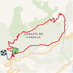

Length
11.5 km

Max alt
1686 m

Uphill gradient
792 m
Km-Effort
22 km

Min alt
1001 m

Downhill gradient
809 m
Boucle
No
Creation date :
2019-11-27 17:51:28.873
Updated on :
2019-11-27 17:52:15.717
4h24
Difficulty : Difficult

FREE GPS app for hiking
 SityTrail
IGN / Geographical institutes
SityTrail Plus
The world is yours!
About
Trail Walking of 11.5 km to be discovered at Auvergne-Rhône-Alpes, Upper Savoy, Passy. This trail is proposed by TRIMAILLE.
Positioning
Country:
France
Region :
Auvergne-Rhône-Alpes
Department/Province :
Upper Savoy
Municipality :
Passy
Location:
Unknown
Start:(Dec)
Start:(UTM)
320304 ; 5089420 (32T) N.
Comments