


Rando Servoz

TRIMAILLE
User
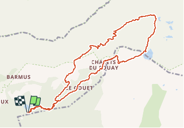

Length
12.6 km

Max alt
1987 m

Uphill gradient
834 m
Km-Effort
24 km

Min alt
1278 m

Downhill gradient
837 m
Boucle
Yes
Creation date :
2019-11-27 17:53:24.181
Updated on :
2019-12-11 11:07:49.083
4h45
Difficulty : Difficult

FREE GPS app for hiking
 SityTrail
IGN / Geographical institutes
SityTrail Plus
The world is yours!
About
Trail Walking of 12.6 km to be discovered at Auvergne-Rhône-Alpes, Upper Savoy, Passy. This trail is proposed by TRIMAILLE.
Positioning
Country:
France
Region :
Auvergne-Rhône-Alpes
Department/Province :
Upper Savoy
Municipality :
Passy
Location:
Unknown
Start:(Dec)
Start:(UTM)
325914 ; 5090809 (32T) N.
Comments