


Rando Émagny

TRIMAILLE
User
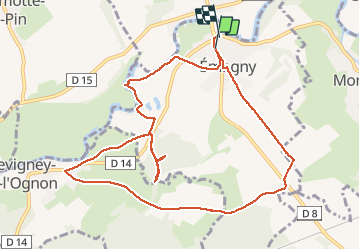

Length
11.1 km

Max alt
242 m

Uphill gradient
132 m
Km-Effort
12.8 km

Min alt
199 m

Downhill gradient
138 m
Boucle
Yes
Creation date :
2019-11-27 17:55:13.351
Updated on :
2019-12-11 11:05:55.487
2h48
Difficulty : Easy

FREE GPS app for hiking
 SityTrail
IGN / Geographical institutes
SityTrail Plus
The world is yours!
About
Trail Walking of 11.1 km to be discovered at Bourgogne-Franche-Comté, Doubs, Émagny. This trail is proposed by TRIMAILLE.
Positioning
Country:
France
Region :
Bourgogne-Franche-Comté
Department/Province :
Doubs
Municipality :
Émagny
Location:
Unknown
Start:(Dec)
Start:(UTM)
716691 ; 5243943 (31T) N.
Comments