


Rando OVS Port-Lesney

TRIMAILLE
User
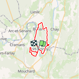

Length
21 km

Max alt
446 m

Uphill gradient
566 m
Km-Effort
29 km

Min alt
236 m

Downhill gradient
568 m
Boucle
Yes
Creation date :
2019-11-27 18:01:36.352
Updated on :
2019-11-27 18:02:27.593
6h05
Difficulty : Difficult

FREE GPS app for hiking
 SityTrail
IGN / Geographical institutes
SityTrail Plus
The world is yours!
About
Trail Walking of 21 km to be discovered at Bourgogne-Franche-Comté, Jura, Port-Lesney. This trail is proposed by TRIMAILLE.
Positioning
Country:
France
Region :
Bourgogne-Franche-Comté
Department/Province :
Jura
Municipality :
Port-Lesney
Location:
Port-Lesney-Grange-de-Vaivre
Start:(Dec)
Start:(UTM)
714635 ; 5209432 (31T) N.
Comments