


Gigots et laueeron

AIGUIER
User

Length
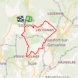
12.7 km

Max alt
548 m

Uphill gradient
337 m
Km-Effort
17.2 km

Min alt
348 m

Downhill gradient
337 m
Boucle
Yes
Creation date :
2019-11-28 08:57:46.5
Updated on :
2019-11-28 13:46:51.601
4h08
Difficulty : Easy

FREE GPS app for hiking
 SityTrail
IGN / Geographical institutes
SityTrail Plus
The world is yours!
About
Trail Walking of 12.7 km to be discovered at Auvergne-Rhône-Alpes, Drôme, Gigors-et-Lozeron. This trail is proposed by AIGUIER.
Positioning
Country:
France
Region :
Auvergne-Rhône-Alpes
Department/Province :
Drôme
Municipality :
Gigors-et-Lozeron
Location:
Unknown
Start:(Dec)
Start:(UTM)
666608 ; 4961859 (31T) N.
Comments