


Laillé

nolsim
User
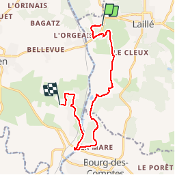

Length
11.7 km

Max alt
102 m

Uphill gradient
274 m
Km-Effort
15.3 km

Min alt
11 m

Downhill gradient
270 m
Boucle
No
Creation date :
2019-11-28 13:14:56.494
Updated on :
2019-11-28 16:12:49.72
2h57
Difficulty : Easy

FREE GPS app for hiking
 SityTrail
IGN / Geographical institutes
SityTrail Plus
The world is yours!
About
Trail Walking of 11.7 km to be discovered at Brittany, Ille-et-Vilaine, Laillé. This trail is proposed by nolsim.
Description
un peu boueux l'hiver !
Positioning
Country:
France
Region :
Brittany
Department/Province :
Ille-et-Vilaine
Municipality :
Laillé
Location:
Unknown
Start:(Dec)
Start:(UTM)
593992 ; 5314638 (30T) N.
Comments