


Culles les roches Les Chaumes page 55

grasgilbert
User
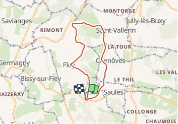

Length
12.1 km

Max alt
439 m

Uphill gradient
326 m
Km-Effort
16.4 km

Min alt
299 m

Downhill gradient
320 m
Boucle
Yes
Creation date :
2019-11-28 12:31:08.553
Updated on :
2025-01-16 17:13:10.859
3h44
Difficulty : Difficult

FREE GPS app for hiking
 SityTrail
IGN / Geographical institutes
SityTrail Plus
The world is yours!
About
Trail Walking of 12.1 km to be discovered at Bourgogne-Franche-Comté, Saône-et-Loire, Culles-les-Roches. This trail is proposed by grasgilbert.
Positioning
Country:
France
Region :
Bourgogne-Franche-Comté
Department/Province :
Saône-et-Loire
Municipality :
Culles-les-Roches
Location:
Unknown
Start:(Dec)
Start:(UTM)
626467 ; 5167940 (31T) N.
Comments
bien
bien