


Rando OVS Nolay

TRIMAILLE
User
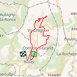

Length
14.3 km

Max alt
519 m

Uphill gradient
499 m
Km-Effort
21 km

Min alt
327 m

Downhill gradient
498 m
Boucle
No
Creation date :
2019-11-29 10:59:51.55
Updated on :
2019-11-29 11:00:23.79
4h22
Difficulty : Very difficult

FREE GPS app for hiking
 SityTrail
IGN / Geographical institutes
SityTrail Plus
The world is yours!
About
Trail Walking of 14.3 km to be discovered at Bourgogne-Franche-Comté, Côte-d'Or, Nolay. This trail is proposed by TRIMAILLE.
Positioning
Country:
France
Region :
Bourgogne-Franche-Comté
Department/Province :
Côte-d'Or
Municipality :
Nolay
Location:
Unknown
Start:(Dec)
Start:(UTM)
624358 ; 5201184 (31T) N.
Comments