


Rando Abondance

TRIMAILLE
User
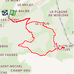

Length
11.6 km

Max alt
1780 m

Uphill gradient
867 m
Km-Effort
23 km

Min alt
940 m

Downhill gradient
868 m
Boucle
Yes
Creation date :
2019-11-29 16:20:07.691
Updated on :
2019-11-29 16:21:07.942
4h35
Difficulty : Difficult

FREE GPS app for hiking
 SityTrail
IGN / Geographical institutes
SityTrail Plus
The world is yours!
About
Trail Walking of 11.6 km to be discovered at Auvergne-Rhône-Alpes, Upper Savoy, Abondance. This trail is proposed by TRIMAILLE.
Positioning
Country:
France
Region :
Auvergne-Rhône-Alpes
Department/Province :
Upper Savoy
Municipality :
Abondance
Location:
Unknown
Start:(Dec)
Start:(UTM)
325578 ; 5128103 (32T) N.
Comments