


Châtel Prés la Joux

TRIMAILLE
User
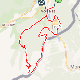

Length
11.3 km

Max alt
1874 m

Uphill gradient
698 m
Km-Effort
21 km

Min alt
1217 m

Downhill gradient
819 m
Boucle
No
Creation date :
2019-11-29 16:46:25.852
Updated on :
2019-11-29 16:47:16.511
4h09
Difficulty : Difficult

FREE GPS app for hiking
 SityTrail
IGN / Geographical institutes
SityTrail Plus
The world is yours!
About
Trail Walking of 11.3 km to be discovered at Auvergne-Rhône-Alpes, Upper Savoy, Châtel. This trail is proposed by TRIMAILLE.
Positioning
Country:
France
Region :
Auvergne-Rhône-Alpes
Department/Province :
Upper Savoy
Municipality :
Châtel
Location:
Unknown
Start:(Dec)
Start:(UTM)
333862 ; 5125244 (32T) N.
Comments