


Rando Châtel Les Mattes

TRIMAILLE
User
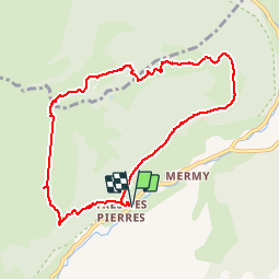

Length
9.2 km

Max alt
1919 m

Uphill gradient
802 m
Km-Effort
19.9 km

Min alt
1164 m

Downhill gradient
805 m
Boucle
Yes
Creation date :
2019-11-29 16:48:11.753
Updated on :
2019-11-29 16:49:21.168
3h54
Difficulty : Difficult

FREE GPS app for hiking
 SityTrail
IGN / Geographical institutes
SityTrail Plus
The world is yours!
About
Trail Walking of 9.2 km to be discovered at Auvergne-Rhône-Alpes, Upper Savoy, Châtel. This trail is proposed by TRIMAILLE.
Positioning
Country:
France
Region :
Auvergne-Rhône-Alpes
Department/Province :
Upper Savoy
Municipality :
Châtel
Location:
Unknown
Start:(Dec)
Start:(UTM)
331221 ; 5124187 (32T) N.
Comments